

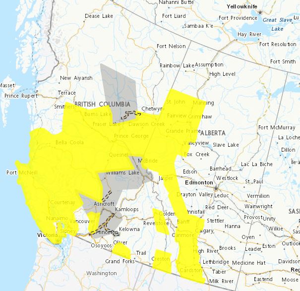
There is a yellow wind warring for the Central Coast, with damaging wind are expected.
A robust low pressure system will track across the Central Coast today.
Ahead of the low pressure system we will see southerly winds 90 kilometers per hour gusting to 110 kilometers per hour developing over the region this afternoon.
In the wake of this low, there is potential that we could see a brief period of very strong westerly wind gusts late this afternoon before the winds ease.
There is also a rainfall warring for the Central coast. From now until this evening.
With total rainfall amounts of 100 up to 175 millimeters expected.
Localized flooding is possible. Some roads may become impassable. Visibility may be suddenly reduced at times.
Stay away from rivers, creeks and culverts.
There is also a wind waring for Central Interior and overnight into the peace district.
A strong sudden push of wind with gusts ranging from 80-100 kilometers per hour.
And lastly there is a special weather statement for South Cariboo, 100 Mile House (Including Highway 97) – South Thompson – Fraser Canyon – north including Lillooet – Williston (Including Pine Pass) – Yellowhead (near West Twin Creek)
It will be bringing a prolonged period of southeast winds with gusts ranging from 60-80 kilometers per hour to the B.C. interior.
These southeast winds will peak this morning with the exception of South Thompson.
Winds may ease slightly this afternoon before an incoming cold front will bring a strong push of southwest winds, with gusts potentially reaching 90 km/h between South Thompson and Mackenzie.
Another potentially strong storm is set to follow on Saturday evening.





Comments